A connector for Claude · Kartverket’s maps and registers
Plan your hike with Claude and Kartverket’s maps.
Claude reads place names, trails, elevation profiles and huts from Kartverket, and the forecast from MET Norway. The map is drawn right in the conversation. The plan is saved to your mtnlabs account and is ready in the MapBridge app.
- Free for now
- You need Claude and an mtnlabs account
- A source and a date on every number
How it works
Add MapBridge to Claude, and sign in with your mtnlabs account when Claude asks.
Ask about a place, or ask Claude to plan the hike. You decide the turnaround time, the finish time and the bail-outs. Claude asks you for them, but never suggests them.
Claude answers with the map in the conversation and saves the plan. You’ll find it in the MapBridge app, even offline.
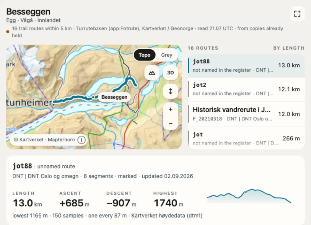
Then ask: “Show me Besseggen” «Vis meg Besseggen»
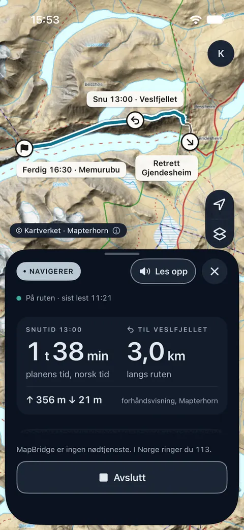
MapBridge on iPhone
The trips Claude saves are in the app, and you can read them offline. Tap Navigate, and you see how long is left until the turnaround time and how far it is to the turnaround point.
If you leave the route, the app tells you on the screen, and aloud when Read aloud is on. It never says whether to go on or turn back.
Sign in to the app with the same mtnlabs account as in Claude. Maps, navigation and GPX work without an account too.
Connect it
You add MapBridge to Claude as a custom connector. Claude then asks you to sign in with your mtnlabs account. You can use Apple, Google or GitHub.
The link opens Claude with the name and address filled in. You review and confirm there, and nothing is added until you do.
https://map.mtnlabs.ai/mcpOr paste the address yourself. One click selects the whole line.
Want the trips on your phone? Here's how to connect the MapBridge app and Claude.
Claude on the web
- Press Add MapBridge to Claude above, or go to Customize › Connectors, press + and choose Add custom connector.
- Check that the address is the same as above, and press Add. Sign in when Claude asks.
- In a conversation, switch MapBridge on under + › Connectors, and ask.
Claude Desktop
- Go to Customize › Connectors, press + and choose Add custom connector.
- Paste the address, name it MapBridge, and press Add. Sign in when Claude asks.
- In a conversation, switch MapBridge on under + › Connectors, and ask.
Claude on iPhone
- The easiest way is to add it on the web or in Claude Desktop first.
- Sign in to the Claude app with the same Claude account. The connector is there the next time you sign in.
- Switch MapBridge on for the conversation, and ask.
As of 30 September 2026: on Team and Enterprise, only the Owner can add a custom connector, and it then applies to the whole organization. The Owner can use this pre-filled dialog. Each member then connects under Customize › Connectors. On Claude Free you can have one custom connector.
Well-known hikes in the register
One page per hike, with what the registers say about it: length, ascent, steward, marking and dates, an elevation profile and the route on Kartverket’s map. Each page is read from the registers when it is made.
What you get
- The map
Where Claude can show maps, you get Kartverket’s topographic map in the conversation, with relief and 3D. You can move the route yourself.
- The route
You choose 2 to 30 places, and the route passes through them. Each point is moved to the nearest trail in Turrutebasen if it lies within 500 m. MapBridge draws only along trails in the register, and the climb is worked out from Kartverket’s terrain model.
- The plan
The date, the start, the turnaround time, the finish time and the bail-outs are saved on your mtnlabs account. You set the times.
- Weather along the route
Wind and precipitation from MET Nordic every 2 km along the route, further apart on long routes. The weather shown is for the time you get there, worked out from your start time and your pace. You decide both.
- Warnings
NVE’s avalanche warning and MET Norway’s weather warnings for the day you ask about, as they were issued.
- Huts and shelters
Tourist huts and shelters from Kartverket’s N50, with service level, owner and whether they are locked, as N50 records it. No public source says whether a hut is open or can be used.
What it costs and what is kept
- Price
Free for now. You use your own Claude, and mtnlabs neither pays for it nor controls it.
- Routes Claude draws
Each route is kept for 30 days after it was last changed. Nothing about you is kept with it: not your account, your IP address or the conversation.
- Your trips
Trips are saved on your mtnlabs account. Claude can read and save trips there, but never gets your position or the tracks you record in the app. Ask Claude to delete everything, and MapBridge removes every trip and everything else it holds for the account.
The boundary
MapBridge is a bridge, not a guide.
MapBridge er en bro, ikke en fører.
It says what is known and where it came from. It does not judge whether a route suits you, it does not decide, and it is never with you on the mountain.
Den sier hva som er kjent og hvor det kommer fra. Den vurderer ikke om en rute passer deg, den bestemmer ikke, og den er aldri med deg på fjellet.
Where the answers come from
Place names and elevation are fetched from Kartverket every time you ask. The forecast, the weather warnings and the avalanche warning are fetched when you ask about a particular day. Trail routes, huts and shelters come from MapBridge’s own copies of Turrutebasen and N50. Wind and precipitation along the route come from a copy of MET Nordic. Every answer shows when the data was fetched. MapBridge stores no map tiles itself.
- Place names
Kartverket, Sentralt stedsnavnregister.© Kartverket · CC BY 4.0
- Trail routes
Kartverket, Nasjonal database for tur- og friluftsruter (Turrutebasen). It holds only routes with a named steward, so a path you see on the ground can be missing.© Kartverket · open data
- Elevation
Kartverket, høydedata: the terrain model at 1 m resolution where it exists.© Kartverket · CC BY 4.0
- Topographic map
Kartverket’s WMTS cache. The map panel and the hike pages load the map straight from there.© Kartverket · CC BY 4.0
- Huts and shelters
Kartverket, N50 Kartdata, in MapBridge’s own copy: building types 956 (tourist hut) and 172 (forest and outfield cabin, turf hut).© Kartverket · CC BY 4.0
- Weather
MET Norway: Locationforecast and Sunrise when you ask about a particular day, and MET Nordic for wind and precipitation along the route and in the map’s weather layer. MapBridge works out the end of civil twilight from the sun’s position.Based on data from MET Norway (api.met.no), CC BY 4.0 (creativecommons.org/licenses/by/4.0)
- Warnings
NVE’s avalanche warning on Varsom and MET Norway’s weather warnings (MetAlerts).Varsler fra Snøskredvarslingen i Norge og www.varsom.no
- Terrain shading
Mapterhorn, over Kartverket’s terrain model.Mapterhorn — see mapterhorn.com/attribution (Norway is built from Kartverket's terrain model, CC BY 4.0)
What it does not have
No conditions report, no snow depth, no opening hours and nothing on hut availability. The forecast comes from MET Norway and is shown with the time it was updated. MapBridge does not judge it. When something is missing from a register, MapBridge says so rather than filling anything in. An ascent that is not given shows as unknown, not as zero.
MapBridge is not an emergency service. In Norway, call 113. MapBridge er ingen nødtjeneste. I Norge ringer du 113.